Monday, August 31, 2009

★ Mount Rainier National Park, WA

Located about 55 miles south of Seattle, WA, this majestic mountain provides many great summer hiking opportunities for the casual weekend hiker. It is actually a dormant stratovolcano formed less than 1 million years ago. The visitor center (Paradise point) sits at an elevation of 5400 feet. Here you can pick up a trail map, get advice from park officials, and use the restrooms.

The Skyline Trail Loop is one of the more popular trails, featuring a 1400-foot elevation change. The hike begins at the visitor center (at Paradise point) and is slightly over 5 1/2 miles round trip, or 4 1/2 miles if you take a shortcut.

Going clockwise along the loop, one begins the uphill portion (about 2 miles) of the hike. Right away, Rainier's stunning beauty can be felt as the well-marked trail meanders through lush tree-lined meadows brimming with wildflowers and animal life. Deer, marmots, and birds often venture within viewing distance of the trail.


As the elevation increases, you can get a better look at the glaciers. Soon the trail reaches its highest point at Panorama point - elevation 6800 feet - where hikers often stop to eat their bag lunches and enjoy breathtaking views of the Cascade range. There is also a nearby restroom.
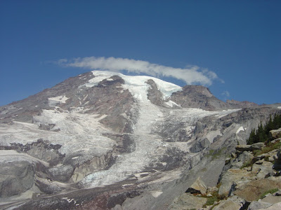


Descending the trail on its east side, hikers overlook a rocky, barren landscape. After about a mile, hikers have the option of returning 1.5 miles to the trail head via the Golden Gate trail, or continuing for 2.5 more miles on the remainder of the Skyline Trail.


Moving further down, the trail transitions back to meadowlands and tree-lined valleys. About half a mile from the trail's end, hikers can stop at Myrtle Falls for a scenic break. Finally the visitor center comes into sight, closing the loop full circle.


Trail: Skyline Trail Loop, 5.5 miles, 1400 ft elevation change
Difficulty: Moderate to Strenuous (elevation change, steep grade, altitude, length)

Sunday, August 23, 2009

Mount Diablo State Park, Clayton, CA

Located in Clayton/Danville, this mountain provides plenty of hiking opportunities. One of the more difficult hikes is the Mitchell Canyon loop, a 14.0 mile hike with a 3400-foot elevation change. For details see
http://www.mdia.org/hikesdifficult.htm#MITCHELL%20CANYON


Note: Difficulty: Strenuous (length and elevation change)

Thursday, August 13, 2009

Baylands Trail, Palo Alto, CA

This Palo Alto trail is next to Shoreline Park in Mountain View. It is great for birdwatching, and good for a weekend jog if you happen to be in the area and don't mind the smell of the birds. The land is very flat and easy on a runner's knees.


Difficulty: Easy to Moderate

Tuesday, August 4, 2009

Half Moon Bay State Beach, CA

This is a beautiful beach just off Highway 1 in the city of Half Moon Bay, that offers 4 miles of sandy and rocky coastline. The following post describes my hike between Dunes and Poplar beaches (and back), which are separated by 1.5 miles of coastline. For a better experience, do check the tides and weather beforehand.

I started my hike at Dunes beach, which is a northern access point. It is not too crowded here and a good place to walk, hangout with family, and sunbathe. There are many bird species here for the bird watching enthusiast.


Walking southbound, the waves get slightly larger until reaching Venice beach (popular with surfers). Continuing, the next beaches are Francis, then Poplar beaches. The coastal cliffs are taller here, and the rock formations are interesting to note. At early to mid-afternoon, it's way past time to turn around for the long walk back.


Note 1: I strongly recommend getting back to your car well before sunset, and bringing a flashlight. It is not safe or fun getting caught in the dark alone with the tide rolling in, finding a ticket on your car, and relying on the park officials to keep the gate unlocked for you. Safety first! Don't let this happen to you!

Mission Peak Regional Park, Fremont, CA

Hidden behind the suburbs of Fremont, this 7-mile (round trip) hike provides a good workout, and a splendid view of the south bay. It has a 2000-ft elevation change, and on the day I went it was uncomfortably warm near the bottom, cool and windy near the top.


Difficulty: Moderate to Strenuous (steep grade, large elevation change, & intense heat during summer months)

Mount Tamalpais State Park, Mill Valley, CA

Just north of San Francisco, this is a great place for the casual weekend day hiker.

The adventure begins with a scenic drive to the visitor center just below the peak. There you have several options. A couple examples... The East peak trail (.5mi round trip) is probably the most popular and provides nice views of the bay. Inspiration point (2.5 mi round trip from visitor center) provides a longer and less crowded option, ideal for bikers and those who want a workout.


Note: Actual date of hike was 8/2/09

★ Yosemite National Park, CA

Situated in Eastern California, Yosemite National Park is an ideal hiking and camping area. One of the most popular trails here is Half Dome, a strenuous 16-mile hike with a 4800-foot elevation change.

The trail head starts out in a woody area, a short drive from the campgrounds. For the first few miles, the path traverses through a damp forest with views of nearby waterfalls that you can almost touch. The woods are teeming with wildlife including deer, squirrels, and evergreen trees. Already the slope is somewhat steep.


Further into the hike, the forest clears out, and vast rock formations become visible in the distance. All the while, the slope gets progressively steeper until the last half mile. Here, cables (held by metal stakes lodged in the rock), gloves, and footholds are provided to assist hikers in scrambling up a moderately steep rock face. Hikers can then celebrate their accomplishment by eating lunch on top of Half Dome (elevation 8840 ft) before beginning their descent. The views of the opposing rock faces are stunning.


But the journey is only halfway done. The descent is another 8 miles, with sunny afternoon views of waterfalls, cliffs, and more woods. During the last stretch of trail, the value of being physically fit and bringing enough food and water become painfully evident. Once the hike is finally complete, however, it's clear that the experience is well worth the effort.


Trail: Half Dome, 16 miles, 4800 ft elevation gain
Difficulty: Strenuous (length, steepness, intense heat during summer months)


Note: These photos were taken in July 2006 (in good company!). Post date is in August 2009 to indicate when this blog was started. In general, post day = hike day unless otherwise specified.